Copyright © 2014-
All Rights Reserved

Updated 02/11/23 7:04 PM
Black Canyon of the Gunnison National Park
Black Canyon of the Gunnison National Park is home to a rushing river which helped to carve a deep chasm that gets little sunlight which gave rise to its black name.
Colorado
2003
About The Park
The Black Canyon of the Gunnison National Park is home to the rushing Gunnison River which helped to carve a deep chasm that gets little sunlight which gave rise to the park’s name.
For me, this was basically a drive by park. We were driving from Moab, UT to Colorado Springs and along the way, on U.S. highway 50, we stopped at the Colorado National Monument and the Black Canyon.
Although I wish I’d had more time to explore it, the park can be seen in a couple of hours if you want to. You can also easily find enough to do for a visit of a couple of days.
The rim can be reached via a graded road from the north near the town of Crawford. The more accessible way is coming in from the south via U.S. 50 east of Montrose, Colorado.
There’s two roads in the park that you can drive. The East Portal road branches off to the right on the park entrance road. This is an extremely steep road (16% grades!) with hairpin curves. It is paved and I didn’t know anything about it when I visited the park and did not take it.
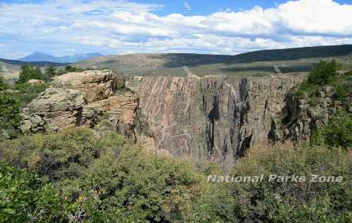
We took the South Rim Road which goes past the visitor center and stopped at a few of the overlooks. The canyon is impressive and the national park is in the steepest and most dramatic part of the canyon. It is very steep and narrow, with sheer cliffs that make it hard for the sun to penetrate – parts of the canyon only get about 33 minutes of sunlight a day. The lack of sunlight leaves parts of it in the dark for most of the day. Thus the name -
The canyon depth varies from 1,800 feet at Gunnison Point to 2,700 feet at Warner Point. The Painted Wall, pictured above, rises about 2,000 feet above the river.
Wildlife
Deer, bears, Rocky Mountain Bighorn Sheep, marmots, coyotes, skunk, badgers, raccoons and mountain lions.
Lodging
There is no lodging in the park. Lodging can be found in Montrose (15 miles), Gunnison (65 miles) and Grand Junction (75 miles) from the visitor center.
Hiking
There’s a number of hiking trails along the rim. The Rim Rock Nature trail, near the visitor center, is a relatively flat, self-
There’s also several other hiking trails in the rim area of varying degrees of difficulty. Getting to the Gunnison River at the bottom of the canyon is a dangerous descent and is for experienced climbers. There are climbing routes which require a permit. There are also ‘scrambling routes’ for people in excellent physical condition who will have to find their way back up.
The NPS says that poison ivy is ‘nearly impossible to avoid’ and can be 5 feet tall along the river.
Black Canyon of the Gunnison National Park Photo Gallery
Other Resources
Black Canyon of the Gunnison National Park -
Black Canyon of the Gunnison National Park -
Colorado National Monument -


Other National Parks and National Monuments Within a Day’s Drive
Canyonlands National Park and Arches National Park These are places of steep canyons and iconic arches and are both outside of Moab, Utah and are about 200 miles to the west and about 3.5 hours.
Petrified Forest National Park Home of the Painted Desert and 225 million year old petrified logs is 417 miles to the west and about 7.5 hours.
Great Sand Dunes National Park is a 30 mile long sand dune with one dune reaching 750 feet high. It is 200 miles to the southeast and about a 4 hour drive.
Capitol Reef National Park This spectacular fold in the Earth’s crust is 290 miles west and about a 5 hour drive.
These national monuments are on Navajo Tribal land and are as worthwhile to visit as any national park.
Monument Valley Tribal Park Famous for its massive sandstone buttes and as a backdrop for many a Hollywood western movie is about 225 miles south and about a 4.5 hour drive.
Canyon De Chelly National Monument Ancient cliff dwellings carved into the sides of a steep canyon is about 350 miles southeast and about a 7 hour drive.
*N*P*Z*
National Parks Zone