Copyright © 2014-
All Rights Reserved

Updated 02/11/23 7:04 PM
Other Resources
Pinnacles National Park on the National Parks Service website -
Pinnacles National Park -
Pinnacles National Park -
Pinnacles National Park -
Pinnacles National Park -
Pinnacles National Park -
Pinnacles National Park
In Pinnacles National Park you can see assemblages of unusual-
California
2014
About The Park
Pinnacles National Park gets its name from the pinnacle-
When you visit the park you are seeing the remains of part of an ancient volcanic field. The volcano was located 195 miles to the southeast. Movement of the Pacific Plate, along the San Andreas Fault, moved two thirds of the volcanic field 195 miles to the northwest which is where the park lies today. The San Andreas Fault currently lies four miles to the east of the park and is visible from some trails if you know what to look for.
Two other large faults run through the park. These faults parallel the San Andreas Fault and were probably caused by movement of that fault. As such, seismic activity is frequent in the park and the U.S. Geological Survey maintains seismometers in the park.
This was an easy 2-
The park is virtually a tale of two parks connected only by a hiking trail over the mountain. The East side has shade and water and the pinnacles while the West side has talus caves to explore. You could hike from either side to the other and back, about a 7 or 8 mile hike, but you can take some nice loop hikes on either side and see more of what the park has to offer.
The central California locale can make for very hot summers so this is a park best visited in the spring and fall. This is partly due to the imposition of the Santa Lucia Mountains between the park and the Pacific Ocean which negates the ocean’s moderating influence. Summer daytime temperatures can exceed 100°F. We were there in May and overall it was pleasant but up on the mountain.
The park’s terrain bears no resemblance to the surrounding foothills. In the park there are ramparts, crags and rock spires along with rock monoliths, sheer-
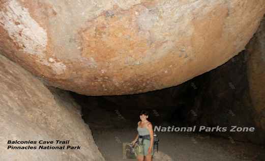
The caves at Pinnacles are talus caves formed when boulders, some rather large, that tumbled down the mountain and lodged in steep narrow canyons. You can see a picture of one of these at the top of the page.
Wildlife
Mammals and birds that inhabit this park include coyotes, skunk, bobcats, raccoons, gray foxes, cougars, wild turkeys, golden eagles, California quail and the great horned owl.
California Condors were reintroduced to the area and the park now has a population of 25 condors.
Several types of rattlesnakes inhabit the park but bites are extremely uncommon. They are protected in the park and, if given plenty of room to slither off, they will do so.
A 1990 census of bees in the park showed that there were 400 different species. This is the most bees per unit area of any place on earth. Most of these bees are solitary and do not live in colonies.
The park has a problem with wild pigs which is the result of the introduction of them by the Spanish in the 1700’s. Wild Boars were also imported for hunting and they interbred with the feral pigs. Considered an invasive species with a negative impact on the park’s vegetation a 24-
Tule elk, pronghorn, black bears and grizzly bears once inhabited the area but were extirpated from here by the end of the 19th century.
Lodging
There is no lodging in the park nor for that matter food. Lodging can be found in the surrounding towns. King City, which is 21 mile south of the park, had a number of motels.
Inn at The Pinnacles
This was a very pretty looking bed-
Keefer’s Inn
Located in King City, this is a typical motel. The rooms were nice and more than adequate.
Hiking
High Peaks Trail
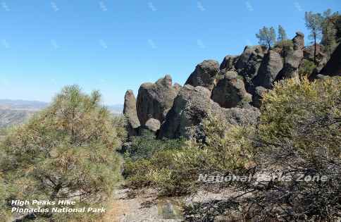
This is a 6.3 mile loop trail. It is a strenuous trail that was rocky, with little shade and some ledges with steep drop-
Balconies Cave
This can be reached from either side but it is a much shorter hike from the west side of the park. From the Chaparral Ranger Station it is only ½ mile to the Balconies Cave Loop (which is comprised of the Balconies Cliffs Trail and the Balconies Cave Trail). The loop is about 1.2 miles making the hike a very manageable 2.2 miles out-
Juniper Canyon to High Peaks
This is a hike from the west side that travels up the mountain to make a loop with the High Peaks Trail. It is 4.5 miles and is a strenuous hike.
Most hiker’s seem to prefer the east side of Pinnacles National Park because there are more trails and more variety. However, High Peaks and Balconies Cave are shorter hikes from the west. Balconies Cave is less than half the distance if you hike to it from the west.
Pinnacles National Park Photo Gallery


Other National Parks Within a Day’s Drive
Channel Islands National Park a unique marine ecosystem is 200 miles to the south and about a 3 hour drive to Ventura, CA where you would get the boat to the Channel Islands. The boat leaves early in the morning.
Kings Canyon National Park and Sequoia National Park where you can visit two great parks that lie adjacent to each other is about 219 miles to the southwest and is a 5.5 to 5 hour drive.
Yosemite National Park is the home of the famed Yosemite Falls and the El Capitan monolith and is 270 miles to the southwest and about a 5 hour drive.
Joshua Tree National Park with its famous Joshua Trees and boulder piles is 430 miles to the southeast and about a 7 hour drive.
Redwoods National Park where the world’s tallest trees can be found is 475 miles to north and about a 7.5 hour drive.
*N*P*Z*
National Parks Zone