Copyright © 2014-
All Rights Reserved

Updated 02/11/23 7:04 PM
Grand Canyon - Toroweap
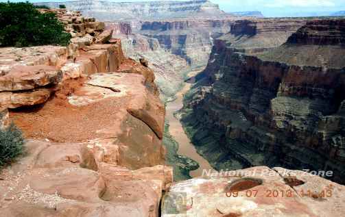
At the Toroweap Overlook, on The Grand Canyon’s North Rim, it is 3,000 feet straight down to the Colorado River. This is the greatest vertical drop into the Grand Canyon.
Grand Canyon Tuweep Area, Arizona
2013
An Off-Road Drive To The Highest Vertical Drop Into The Grand Canyon
The drive to Toroweap on the North Rim of the Grand Canyon was everything I had hoped it would be. Having seen pictures of it I knew it was a place that I wanted to get to. The problem is that it is 61 miles down a dirt road on the Kaibab Plateau to the edge of the Grand Canyon. The overlook is known as the Toroweap Overlook. The National Parks Service calls that section of the North Rim, where the overlook is located, the Tuweep Area.
Toroweap takes its name, as so many others in the area do, from the geologic layers laid down over the eons. The Toroweap Formation is a 200 foot thick layer of gypsum, shale and sandstone from 273 million years ago. It sits directly below the Kaibab limestone of the Kaibab Formation which is what you are driving on when you are on the Kaibab Plateau.
This is not the kind of place that you want to drive your standard Hertz or Avis rent-
With all of this in mind I had made arrangements with Xpress Jeep Rentals of Kanab, Utah to rent a jeep for the day. We got up early and picked up the Jeep at about 8 o’clock in the morning and headed south out of Kanab towards Fredonia, Arizona. In Fredonia we made a right turn onto Highway 389 traveling west and about 7 miles down the road there was a turnoff for the dirt road that leads to Toroweap.
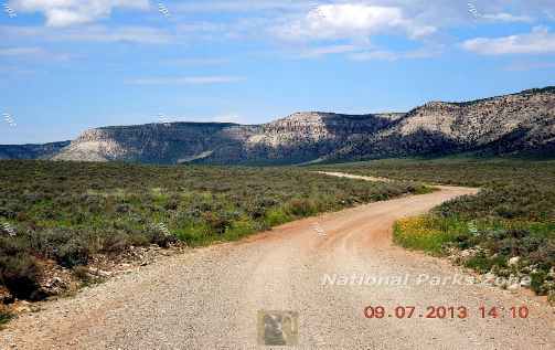
For the first 40 miles or so the road is in fairly good shape. It’s a wide graded road that gets a good amount of truck traffic due to some mining in the area. I felt comfortable doing 40 miles an hour. Some cars and trucks go faster, maybe hitting 50 miles an hour, but since I didn’t know the road, and past experience has shown me that things can pop up unexpectedly, I kept my speed down. While there are some forks in the road along the way, and little in the way of signs, I had a decent map and a GPS and had no trouble following the road. Up ahead we could see that there was rain moving from east to west and that certainly did not make me feel good because it can quickly put the trip in jeopardy. I also kept my eye on what was doing behind me figuring that if I ran into heavy weather up ahead I could always turn back as long as it wasn’t raining behind me. We experienced a bit of light drizzle now and then and pressed on.
At one point, on a practically flat section of road, the right wheel of the car suddenly skidded off to the right into a small gully. I slid along the gully and forced the wheel back on to the road. Once I stopped and got out to take a look at the tires I saw that they were caked with red clay and looked like racing slicks. The moisture from the light rain had dampened the red clay that was the driving surface at that point. This, combined with some puddles that we went through, had left the tires caked smooth with red mud. Since it wasn’t raining anymore I just drove slowly, stopping and getting out to check the tires every few minutes. I saw the caked mud had dropped away from the jeep’s tire treads and I was able to relax a bit. But I learned something. There are places along the road where there was enough of a drop off to roll a jeep and I was lucky that I only ran into a very shallow gully.
The scenery is mostly high desert. Low shrubbery and mountains on both sides of the road. No big mountains, just small mountains and cliffs. While we had occasionally passed a car that was heading back toward the highway by the time we reached the ranger station we hadn’t seen any vehicle in quite some time. The ranger station really is just a house and some small buildings and we saw no sign of life there. I did notice there was an air pump but little else. The ranger station is about 53 miles from the highway. Beyond there the road became narrower to the point that it would’ve been difficult to pass another car coming from the other direction. At this point you’ve been in the Toroweap Valley for a while and the scenery really is beautiful.
About 3 miles from the rim is where the road gets really rugged. At this juncture there is a parking area for low-
As expected the view was spectacular. We got lucky with the weather. The showers that we were watching ahead of us for a good part of the morning had dissipated, the sun was shining and we felt privileged to have made it out there to enjoy a scene that relatively few people get to experience. Standing on a ledge above the Colorado River, with a drop-
There was a restroom there but other than that there was nothing. There are some nice hikes that one can take out there. There’s one to a volcanic cinder cone and there is a campground along the rim for those who care to spend the night. The limiting factor, on a day trip, is time.
The trip back took us about the same amount of time as the trip out. Each way was about a 3½-
At one point on the trip back I saw this white car coming at me. I slowed down and saw that it was a big Chrysler 300 sedan and we both stopped to talk. It was 4 o’clock in the afternoon and in the car were three German tourists heading out to Toroweap. I didn’t want to rain on his parade, but I had to tell him there was no way that car was going to make it out to Toroweap. Had he even tried to take it those last 3 miles he would have probably got stuck out there. I told him that it would be best to park his car and hike the last 3 miles once the road got really rugged. There was no way that, at that hour, he had any chance of not having to drive back at night. He drove on and we continued on our way out. By the time we got back to our hotel it was about 6 o’clock and, looking out towards the Kaibab Plateau, I could see that it was raining hard out there. I would love to know how that guy made out. If he was lucky he turned around and was able to drive back out. The NPS, in their notes on preparedness, makes reference to summer as the ‘monsoon’ season
Toroweap Overlook is one of those beautiful places that few people get to see. Much of the fun is the 61 mile drive across the Kaibab Plateau to get there. It’s not difficult back country driving, but you do need the right equipment if you plan to take it all the way to the end. You could probably take a rented SUV to within three or four miles of the rim, park the car, and hike the rest of the way to the rim. With a good four wheel drive vehicle making it all the way is not a problem so long as you’re not in a big hurry and have some knowledge of how to handle it. But you have to keep in mind that this is very remote country and, should you need emergency assistance, you may not get it.
Wildlife
The usual desert wildlife: snakes and lizards
Lodging
There is none here. There is ample lodging in Kanab, Utah. Lodging can also be found in Fredonia, Arizona, which is closer, but more limited.
Hiking
You can meander about the area but there are no designated hiking trails.
Please Take Note: There is no water, gas, food, lodging, or phone service here.
If you have an interest in going to Toroweap you should definitely read the NPS web page on this. The link is below.
Toroweap Photo Gallery
Other Resources
Toroweap -
Xpress Jeep Rentals -


Other National Parks Within a Day’s Drive:
Anyone visiting Toroweap is probably staying in either Kanab, UT or at the Grand Canyon North Rim.
Bryce Canyon National Park is about 100 miles from Kanab and about a 2 hour drive.
Zion Canyon National Park is about 43 miles from Kanab and about an hour drive.
Grand Canyon National Park -
*N*P*Z*
National Parks Zone